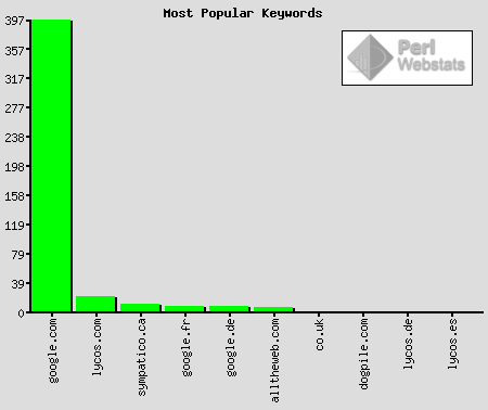
| Page |
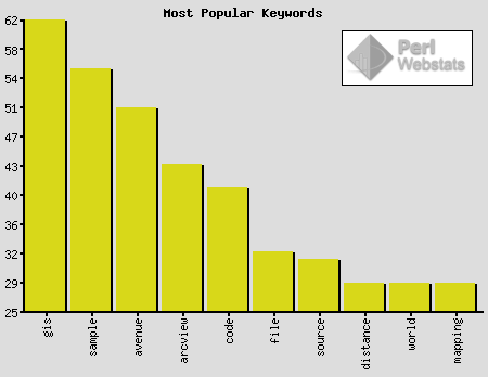
Keywords |
| co.uk |
|
| /gis/project/update1/tasks1.htm |
to (1), microsoft (1), conversion (1), project (1) |
| /gis/maproj/earthdims.htm |
dimensions (1), earth (1) |
| /gis/project/update2/tasks2.htm |
to (1), microsoft (1), conversion (1), project (1) |
| /gis/mapinfo/assignmentthree/index2.htm |
sql (1), records (1), update (1), duplicate (1), creates (1) |
| passagen.se |
|
| /resume/ |
mapbasic (1), download (1), manual (1) |
| dogpile.com |
|
| /gis/apredit/ |
arcview (1), apr (1) |
| /gis/maproj/earthdims.htm |
dimensions (1), earth (1) |
| /resume/ |
resume (1), gis (1), toronto (1) |
| google.com |
|
| /gis/project/GISmeta/ |
gis (2), view (1), layering (1), on (1), crisis (1), geography (1) |
| /gis/raster/assignmenttwo/ |
eucalyptus (7), africa (6), plant (2), temperature (1), climate (1) |
| /gis/geospat/netdist/q2.htm |
euclidean (5), distance (5), gis (1), matrix (1) |
| /gis/maproj/srs.htm |
method (1), t-square (1), to (1), units (1), measurement (1), rectangular (1), co-ordinates (1), angular (1), coordinates (1), spherical (1), parallel (1) |
| /gis/hybrid/interpolation/ |
interpolation (14), gis (7), idw (3), ontario (3), point (2), data (2), spline (2), arcview (2), points (2), climate (2), contour (1), temperature (1), model (1), interpolation,gis (1), algorithms (1), case (1), minimum (1), curvature (1), visibility (1), mapinfo (1), software (1), tin (1), sample (1), values (1), triangle (1), study (1), normals (1), gridding (1), contours (1), variance (1), quintic (1), between (1) |
| /gis/raster/assignmentone/ |
fundamentals (1), gis (1) |
| /gis/project/pres/tsld004.htm |
ottawarealestate (1) |
| /gis/avenue/ |
avenue (18), programming (16), gis (3), gis-avenue (1) |
| /gis/cPlusPlus/calculator/calc.txt |
zero (1), by (1), calc.cpp (1), integer (1) |
| /gis/project/outline/ |
gps (1), activex (1) |
| /gis/cPlusPlus/sampleCode/samples/2-10.txt |
passes (1), failures (1) |
| /gis/avenue/ipcdiadsgn/ |
dialog (2), development (1), excel (1), designer (1) |
| /gis/maproj/ |
mapping (1), projections (1) |
| /gis/hybrid/indexoverlay/ |
orleans (1), population (1), ontario (1) |
| /gis/cPlusPlus/ |
programming (1), calculator (1) |
| /gis/avenue/morestats/scripts/ |
scripts (10), avenue (10) |
| /gis/avenue/datatoolsaccess/ |
api (3), arcview (2), avenue (2) |
| /gis/worldfile.htm |
file (21), world (18), worldfile (7), format (6), arcview (5), tfw (5), esri (5), rotation (2), gis (2), .tfw (2), map (1), image (1), files (1) |
| /gis/vector/ |
vector (2), gis (2) |
| /gis/cPlusPlus/sampleCode/ |
sample (53), code (32), programs (23), source (22), sort (3), gis (2), minmax (2), cplusplus (2), -visual (1), -re (1), -documentation (1), -c (1), sample() (1), for (1) |
| /gis/geospat/dem/trend.gif |
interpolation (1), cache:www.kralidis.ca/gis/geospat/dem/ (1), spline (1), explained (1) |
| /gis/project/update1/ |
sample (1), dataflow (1), diagram (1) |
| /gis/project/GISmeta/22feb2000.htm |
gis (2), view (1), openshaw (1), geography (1), crisis (1), on (1) |
| / |
arcinfo (2), hack (2), si4000.inktomi (1) |
| /gis/cPlusPlus/arraysPointers/ |
pointers (18), strings (16), arrays (7), to (7), array (4), pointer (3), with (2), arithmetic (2), copying (2), cplusplus (1), mm-dd-yy (1) |
| /gis/raster/assignmentone/QuestionTwo.htm |
image (1), raster (1), gis (1) |
| /gis/avenue/advqueclass/scripts/ |
scripts (6), avenue (6), layout (2), advanced (1) |
| /gis/mapinfo/ |
mapping (1), choropleth (1), what (1), is (1) |
| /gis/mapinfo/assignmentthree/index2.htm |
sql (3), records (3), duplicate (3), household (2), salary (2), selection (2), site (2), canada (2), gis (2), average (2), concatenating (1), find (1), neighbour (1), analysis (1), columns (1), table (1), mapinfo (1), number (1), mapping (1), pizza (1), catchment (1), area (1), outlet (1), drivers (1) |
| /gis/geospat/dem/spline_view.png |
interpolation (1), cache:www.kralidis.ca/gis/geospat/dem/ (1), spline (1), explained (1) |
| /gis/project/screenshots/ |
hi-res (1), gis (1), screenshots (1) |
| /gis/cPlusPlus/sampleCode/samples/incrmt01.txt |
cout (1) |
| /gis/geospat/dem/ |
elevation (5), idw (4), data (4), interpolation (4), slope (4), degree (4), percent (4), dem (3), algorithm (3), digital (3), model (2), arcview (2), explained (2), inverse (2), distance (2), weighting (1), for (1), table (1), spline (1), variance (1), tin (1), hillshade (1), averaging (1), weighted (1), city (1), mean (1), gis (1) |
| /gis/hybrid/visualization3d/ |
visualization (2), geographic (2) |
| /gis/project/update2/ |
vb (2), chart (2), gantt (2), analysis (1), mapobjects (1), source (1), code (1), network (1) |
| /gis/geospat/netdist/ |
distance (11), arcview (4), dijkstra (4), manhattan (4), euclidean (3), street (2), direction (2), gis (2), fire (2), analysis (2), a* (2), definition (2), path (2), - (2), service (2), area (2), rede (2), shortest (1), most (1), station (1), metric (1), allocation (1), algorithm (1), school (1), network (1), castlefrank (1), route (1), kanata (1), calculation (1), elementary (1), distance, (1), utm (1), reliable (1) |
| /gis/geospat/imageregwarp/ |
arcview (11), image (11), warping (9), world (8), registration (6), file (6), files (2), transformation (2), gis (2), for (2), .jpgw (2), rms (2), affine (2), error (2), code (2), convolution (1), shapefiles (1), polynomial (1), jpeg (1), cubic (1), coverage (1), determine (1), application (1), pixel (1), jpgw (1), data (1), tiff (1), software (1), *.jpgw (1), resampling (1), size (1), theory (1), nad (1), imagewarp (1) |
| /gis/geospat/gridata/ |
grid (6), arcview (3), avenue (2), query (1), data (1), size (1), analysis (1), projection (1), esri (1), table (1), grid.make (1), theme (1), canada (1) |
| /gis/avenue/ipcdiadsgn/scripts/ |
dialog (1), designer (1), exporttoexcel (1) |
| /misc/funpics/ |
pics (17), fun (11), acapulco (3), fun-pics (3), beach (2), baja (1), vacation (1), california (1), gti (1), cool (1), my (1), index (1) |
| /gis/arcinfo/ |
select (1), world (1), info (1), esri (1), file (1), format (1), sql (1), arc/info (1), arc (1) |
| /gis/geospat/geoweb/proposal.htm |
proposal (3), project (2), outline (2), sample (1), web (1), community (1) |
| /gis/project/poster/ |
real (1), gis (1), estate (1) |
| /gis/cPlusPlus/calculator/ |
calculator (3), flowchart (3) |
| /gis/project/poster/tsld004.htm |
inter (1), communication (1), process (1) |
| /gis/avenue/datatoolsaccess/scripts/ |
avenue (11), scripts (10), basic (1) |
| /gis/project/poster/tsld006.htm |
gis (1), dataflow (1) |
| /gis/apredit/ |
command (2), file (2), arcview (1), arguments (1), tool (1), with (1), apr (1), editor (1), shapefile (1) |
| /cgi-bin/getstory.cgi |
wrestlemania (13), results (9), predictions (4), for (1), on (1) |
| /gis/project/discussion/ |
real (1), methods (1), gis (1), estate (1) |
| /gis/mapinfo/assignmentthree/ |
strength (1), site (1), gis (1), selection (1) |
| /gis/mapserv/ms_demo/demo_init.html |
demo (1), mapserver (1), mapserv (1) |
| /gis/mapinfo/assignmenttwo/ |
choropleth (24), mapping (19), software (5), density (4), dot (4), analysis (2), example (1), mother (1), maps (1), thematic (1), limits (1), tongue (1), class (1) |
| /gis/project/deliverables/scripts/ |
exporttoexcel (2) |
| /gis/cPlusPlus/sampleCode/samples/1-27.txt |
formula (13), circumference (10), diameter (8), radius (3), from (1), pi (1) |
| /gis/ |
gis (8), programming (7) |
| /gis/apredit/apredit |
arcview (1), from (1), project (1), command (1), line (1), open (1) |
| /gis/mapinfo/assignmentone/ |
mapping (5), parcel (3), cadastral (2), address (1), to (1) |
| /gis/mapinfo/assignmenttwo/frMtDistance.gif |
mapping (1), cache:www.kralidis.ca/gis/mapinfo/assignmenttwo/ (1), software (1), thematic (1) |
| /gis/vector/assignmentTwo/ |
statistical (1), gis (1) |
| /wrestling/tapes/ |
video (15), wrestling (14), college (6), raw (3), tapes (3), undertaker (2), returns (2), archive (2), kid (2), last (1), usa (1), st. (1), war (1), louis (1), is (1), on (1), rock (1) |
| /gis/geospat/datamod/ |
data (11), modelling (11), growth (1), map (1), classification (1), landuse (1), weighted (1), what (1), urban (1), arcview (1), about (1), is (1), ontario (1) |
| /gis/hybrid/networkanalysis/ |
network (6), analysis (6), gis (5), vector (2), raster (2), comparison (1), with (1), compared (1), arcview (1), transit (1), software (1), based (1) |
| /resume/ |
resume (5), ottawa (4), developer (3), or (2), web (2), toronto (2), java (2), gis (2), xml (2), ontario (2), unix (1), example (1), spatial (1), skills (1), visual (1), application (1), algorithms (1), utm (1), contract (1), -submit (1), fred (1), online (1), landsat (1), format (1), linux (1), sql (1), basic (1), communication (1), oracle (1), -send (1), design (1), inter (1), education (1), converting (1) |
| /gis/maproj/earthdims.htm |
earth (13), dimensions (13), are (2), what (2), statute (1), miles (1), earth-dimensions (1) |
| /gis/project/deliverables/GEOHome.pdf |
maintanence (2), free (1), sbn (1), system (1), dll.make (1), ascii (1), tabular (1), statistics (1), signoff (1), example (1), prototyping (1), arcview (1), concerned (1), parameters (1), names (1), hotlink (1), england (1), data (1), document (1), extraction (1), java (1), development (1), laboratories (1), databases (1), shellexecutea (1), print (1), user32.dll (1), source (1), shapefile (1), operation (1), excel (1), website (1), at (1), class (1), foreach (1), cost (1), geocoded (1), code (1), worksheet (1), extension (1), housing (1), examples (1), process (1) |
| /gis/project/update1/tasks1.htm |
export (1), chart (1), do (1), microsoft (1), geocode (1), project (1), how (1), perl (1), gantt (1) |
| /gis/cPlusPlus/arraysPointers/questionOne.txt |
cpp (1), converter (1), cin (1), date (1), ignore (1), arrayspointers (1), character (1) |
| /gis/geospat/dem/idw_view.png |
interpolation (1), cache:www.kralidis.ca/gis/geospat/dem/ (1), spline (1), explained (1) |
| /gis/geospat/costdist/ |
distance (8), cost (6), arcview (4), grid (2), euclidean (2), model (1), grids (1), least (1), analyst (1), friction (1), gis (1), direction (1), surface (1), applications (1), scenarios (1), path (1), weighted (1), script (1), functions (1), spatial (1), manhattan (1) |
| /gis/avenue/advqueclass/ |
access (1), query (1), list (1), selection (1), box (1), multiple (1), records (1) |
| google.fr |
|
| /gis/geospat/dem/ |
shp (1), hillshade (1) |
| /gis/avenue/morestats/scripts/ |
scripts (1), avenue (1) |
| /gis/cPlusPlus/sampleCode/ |
source (8), code (5), minmax (1) |
| google.de |
|
| /gis/worldfile.htm |
worldfile (1) |
| /misc/funpics/ |
fun-pics (4), pics (2), fun (2), www.fun-pics.de (1), cool (1) |
| /gis/project/deliverables/GEOHome.pdf |
txt (1), dbf (1), perl (1), script (1) |
| /misc/firstwebpage/home0428.html |
homepage (1), undertaker (1) |
| /gis/avenue/datatoolsaccess/scripts/ |
scripts (1), avenue (1) |
| /gis/cPlusPlus/sampleCode/ |
-source (1) |
|