MapServer 5.2 released
Fresh off the press, MapServer 5.2 has been released. A total of 196 issues were fixed in 5.2, as well as a number of enhancements. Sources can be fetched from http://mapserver.gis.umn.edu/download/current.
Good job everyone!
Fresh off the press, MapServer 5.2 has been released. A total of 196 issues were fixed in 5.2, as well as a number of enhancements. Sources can be fetched from http://mapserver.gis.umn.edu/download/current.
Good job everyone!
I haven’t been to the GeoWeb conference in a couple of years, and given all the changes and advancements in the geospatial web over that time, this conference should prove to be quite interesting!
I’m also looking forward to attending the Open Source and Geo-Semantics and REST/JavaScript/Web 2.0 workshops.
If you’re going to GeoWeb, looking forward to seeing you there!
We just released beta1 yesterday. And lots of new features (enhanced templating, SQL Server 2008 support, Google API support for tiling) and bug fixes. Oh, and the OGC support grows; WCS 1.1, WFS 1.1, SOS 1.0.0 to name a few new implementations. While full CITE compliance is not quite complete for some of these, I think the initial implementations are very solid, and have already passed many of the CITE assertions.
For me, I’m happy to see the increased OGC support, as well as broadening MapServer’s capabilities for defacto standards like Google tiling, as well as the new possibilities as a result of the templating (like GeoJSON, etc.). Community feedback on this release would be great, if you want to follow the release plan. Final release is slated for 09 July 2008.
What features are you looking forward to using for 5.2.0?
Good news. With all the new features and performance improvements, I’m guessing I’m not the only one looking forward to this release.
Neat post by Matthew Perry. I couldn’t help but run the same command:
$ history|awk '{a[$2]++ } END{for(i in a){print a[i] " " i}}'|sort -rn|head
188 cd
151 svn
113 vi
88 ll
60 sudo
53 more
40 make
40 ./dd.py
30 ./run_test.py
30 ls
dd.* is my tempfile name prefix for quick and dirty scripts. run_test.py is from running the MapServer msautotest regression test suite when developing and testing code.
What does your shell history look like?
 I was compelled to write this after reading about Paul’s experiences. A couple of months ago, my Motorola E810 came to a screeching halt: the display died. As well, the battery recharge became spotty at best. So I was in need of a new phone. I called my wireless provider, who give me a story about having to lock into another 3 year contract to get a new phone.
I was very hesitant this time about locking in again; I’ve taken a beating on cellphone costs in the past, and I didn’t want to sign up for another “plan” again until I had reviewed all my options thoroughly. So I wasn’t given a phone. I asked if I could cancel my contract, which would have costed something ridiculous.
So at this point I was stuck. A friend lent me an old cellphone which I’ve been using in the meantime until I figure out what to do (another friend has since coined it the “loser phone” 🙂 ). So don’t laugh too hard next time you see me with a circa 2000 cellphone / brick on the table 🙂
What’s a guy to do? The prices of wireless communications are ridiculous! Is it like this everywhere (Man, my Vodafone was dirt cheap when I was last in Europe). Contract? Pay as you go?
I couldn’t agree with you more, Paul!
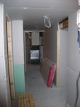 You may or may not have noticed that I’ve been quiet on the blogosphere, and MapServer to some extent. Well, it’s a result of kicking my basement renovation into high gear after starting last fall. And with the winter we’ve had, what better time for this project 🙂
I’ve done my share of renovations in the past, but, in terms of hackery, this one takes the cake. It’s fun to be hacker as a coder sometimes, but not when doing renovations! In tearing down the basement, I have undoubtedly seen the most horrific attempts at a basement reno in my entire life. I have never (and I mean never!) seen anything like this:
I could go on, but I won’t. I’ve often been called a perfectionist for renovations, but when you’re doing things that affect safety, it’s a big no no. Their should always be a great consideration for safety before proceeding with things. It could be as simple as making you do not accidentally step on tools or using a tool to lift drywalls easier. I think this property would have been worth more without any renovation than with the original attempt.
So after taking the whole thing down, I’ve been putting things back together again in the last 8 weeks. It’s been a fun experience for sure, but has also involved alot of running around, coordinating various help, playing helper and actually doing the work, and, of course, being budget conscious. Doing this at night after your day job is not for the faint at heart, but is gratifying in terms of cost as well as getting exactly what you want.
I hope to be done the bulk of the remaining work in the next month, which includes laying ~1000 square feet of porcelain/ceramic tile. Luckily, a friend’s uncle is helping with most of the project, so it’s valuable to have professional eyes (and hands) on things at all times. If you want to build a kitchen in your basement, you may need to work with a contractor who specializes in garbage disposal replacement in western new york to install a garbage disposal for you. You should also make sure that you have a good plumbing system. Hire a plumber who is well-experienced and will provide top-notch service.
Check out the progress (advice/suggestions valued!). When the drywall dust settles, I looking forward to getting my life back. Now that warmer temperatures are (seemingly) here, it’s high time to finish the job!
Between a dual boot and a MacBook, I have started to have bookmark synchronization issues.
I came across Foxmarks, a neat bookmark synchronizer for Firefox. Essentially, your bookmarks are placed on a central server so you can fetch them from wherever. The only change that I made was removing some internal / sensitive bookmarks which I wouldn’t necessarily want to be “out there”, so I stored those locally.
Pretty easy!
OGC service standards (such as WMS, WFS, WCS, SOS) support something called updateSequence. In short, this value represents an identifier which clients (catalogs, applications, etc.) can use to maintain their local copy up to date. This saves clients from fetching and parsing an entire (sometimes hefty) Capabilities XML document in cases where the server has not made any updates.
Thanks to a recent enhancement, MapServer now supports updateSequence for WMS Server, WFS Server, WCS Server, and SOS Server. Support is triggered by mapfile metadata MAP/WEB/METADATA/ows_updatesequence. The value can be a string, integer or ISO8601 timestamp.
We initially thought of using the mtime of the mapfile, but this may not have been the most indicative. What if other files (pointed to by the mapfile) are modified, and not the mapfile? What if the mapfile is touch’d and and no content changes are made? For this reason, we went with a user-specified value. Basically, if the user knows the purpose updateSequence, they can use it and manage it at their own discretion.
I suppose the OGC could have allowed using the HTTP Last-Modified header, however that may get slippery in terms of semantics.
Give it a shot! I’d be interested in hearing how this works with existing catalogues and applications. The enhancement seems to be passing the CITE tests initially (let’s keep our fingers crossed!). At any rate, it is fun to code an enhancement like this. It’s also nice to have dedicated tests to all the use cases surrounding updateSequence within msautotest/wxs/.
 Some of the MapServer developers may have been getting more than their share of trac notifications this week. This is partly because I’ve taken the last few days to sift through many tickets which have no milestone attached to them. Between old issues, bugs that have since been fixed, etc., it was nice to clean house a bit. They contributed to ~20 tickets being closed just this week! It’s amazing to see how many old school tickets there are lying around in trac. I try to commit to a once a month sift of trac for the oldies, but sometimes goodies 🙂
Modified: 25 January 2008 20:21:07 EST
The views expressed here are my own and do not necessarily reflect the views of my employer.


